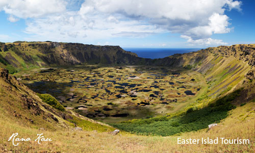
viernes, 30 de diciembre de 2011

Istria. Croatia

Blue seas, white stone and the green interior make up the colour scheme of Istria, the largest peninsula in Croatia. The blueness of its shoreline is contrasted by the lush greenery of its interior and the tiny, “acropolian” towns which, themselves somewhere between waking and sleeping, erase that thin line that divides the real from the illusion. And turn into your very own story.
The heart-shaped peninsula reaching deep into the clear blue waters of the Adriatic Sea is a hidden garden of beauty which opens the door to the sunny and warm Mediterranean. Come and travel through it without hesitation, and the holiday of your dreams will become reality. Multicultural and hospitable, this is an area where wide-ranging diversities have come together to form a happy union. Istria’s crystal clear sea, clean shores and ports, its lively fishing boats and teeming narrow stone streets exude the true charm of the Mediterranean. Small, picturesque medieval towns perched on the peaks of its hills emanate the peace and gentleness of landscapes that irresistibly evoke the most beautiful parts of Tuscany or Provence.

jueves, 29 de diciembre de 2011

Volcanoes of Easter Island


Rano Raraku

Most of the 900 moai in the island come from the slopes of the Rano Raraku volcano. In this unique place, hundreds of sculptors and artists worked between the years 1000 and 1680 to produce giant statues of volcanic stone. Huge burins of basalt, the toki, made it possible to separate the giant sculptures from the flanks of the volcano before finishing them. Today, the visitors who walk through the external and internal slopes of the Rano Raraku can contemplate several tens of these impressive statues, most of them with their body buried. We also know there are moai that were covered by dirt, landslides, rubble and vegetal remains. In this site, a total of 397 moai were counted. Except for their hat (pukao), which came from a quarry near Hanga Roa (Puna Pau), their eyes (made of coral, obsidian or tuff) and their ornamentation, the manufacturing process of the moai was executed almost completely in the same place.


Rano Kau

Rano Kau has a crater lake which is one of the island’s only three natural bodies of fresh water. Most of the volcano is on the coast and has been eroded back to form high sea cliffs which at one point have started to bite into the crater wall. On its northern side, the volcano slopes down to Mataveri International Airport.

Rano Kau is in the world heritage site of Rapa Nui National Park and gives its name to one of the seven sections of the park. The principal archaeological site on Rano Kau is the ruined ceremonial village of Orongo which is located at the point where the sea cliff and inner crater wall converge. One ahu with several moai was recorded on the cliffs at Rano Kau in the 1880s, but had fallen to the beach by the time of theRoutledge expedition in 1914. As well as basalt, it contains several other igneous rocks including obsidian (for which it was one of the major sources for the island’s stoneworkers) and pumice. The crater is almost a mile across and has its own micro climate. Sheltered from the winds that dry most of the rest of the island, figs and vines flourish at Rano Kau


Terevaka

The Mauga Terevaka is the highest point of the island, and also the most recent. It emerged during the last volcanic phases of Rapa Nui, about 250,000 years ago. This summit is 511 m high and is surrounded by other two tops, the Maunga Puka and the Maunga Kuma. Further down there is a crater lake, the Rano Aroi, which is the third fresh water reserve in the island (along with the Rano Raraku and the Rano Kao.) This place does not present much archeological interest, but the visitor can see the whole island from this viewpoint. It is an ideal space for footing and jogging lovers, and also for people looking for some peace and quiet. During the hot summer, it is a cool spot. In the summit of the Terevaka the wind always blows.


The Poike

Located to the east of Rapa Nui, it is crowned by the Maunga Pua ka Tiki and the small domes of the Maunga Parehe: Maunga Tea Tea and Maunga Vai a Heva. This eroded mountain 370 m high is the oldest from a geological point of view, and presents a volcanic structure which is different from the rest of the island. The whitish lava of this peninsula is a type of white trachyte that the current artisans use to carve the moai. The lack of stones in the ground of this area dedicated to stockbreeding is not a result of the superhuman labor of a legion of slaves, but of the own nature of the land. On the southern side, the Maunga Vai a Heva presents an original sculpture oriented to the summit, a sort of giant gargoyle whose mouth was possibly used to collect rainwater. Beyond the three small hills to the north of the Poike, the visitor can admire some petroglyphs shaped as hooks, and above all, five moai made of white trachyte at the Kava Kava ahu. Finally, the visitor can access many caverns on the cliff with a local guide and certain difficulty. One of them served as a cemetery, and the most famous, Ana O Keke, was used to initiate noble young virgins.

miércoles, 28 de diciembre de 2011

Abbottabad. Pakistan.


It is a charming town spread out over several low, refreshingly cool and green hills. Abbottabad is 116 km (2 hours) from Rawalpindi and 208 km (3 hours) from Peshawar. Places worth visiting in Abbottabad are: Simla Hill, Ilyasi Masjid etc.

Abbottabad, is 1,222 m. above sea level, is a neat and clean town in a spacious valley surrounded by green hills. It is a popular summer resort. It serves as a base for trips to Kaghan valley and the Gallies. PTDC maintains a Tourist Information Centre here to facilitate the visitors. Places worth visiting in and around Abbottabad are; Ilyasi Mosque with a water spring, Shimla hill view point. Thandiani is another attractive hill resort 30 km east of Abbottabad at an altitude of 8,800 feet.

martes, 27 de diciembre de 2011

Maririus Inland


L’Aventure du Sucre

Visit an interactive and ultra modern exhibition situated at the heart of an ancient sugarmill and discover the fascinating history of Mauritius and its sugarcane adventure exposed over 5000 sq meters! Then, let yourself be tempted by our tropical boutik with its unique gifts, souvenirs and tasting of special unrefined sugars as well as local rum. Do not miss the opportunity to relish authentic Mauritian cuisine with refined flavours at our restaurant "Le Fangourin".
Open 7 days a week from 09h00 to 18h00 - Free access to the restaurant and the Village Boutik


Ganga Talao - Grand Bassin
Beyond La Marie and Mare-aux-Vacoas is found one of the two natural lakes of Mauritius. It rests within the crater of an extinct volcano. Ganga Talao is an important pilgrimage site and many Mauritians of the Hindu faith walk there during the Maha Shivaratri festival or the night fasting dedicated to Shiva.

Black River Gorges

This national park of 6,574 hectares was created in 1994 for the protection of Mauritius’ remaining native forests. Visitors can enjoy magnificent landscapes, with endemic plants and rare bird species. A trail leads from the Pétrin information centre to an area of typical plant life and to a conservation area. orchids.
Eureka
An old Creole residence built in 1830, Eureka is an essential place to visit during your stay in Mauritius if you wish to immerse yourself in tropical sweetness.

viernes, 23 de diciembre de 2011

Dalmatia - Zadar. Croatia


The Zadar region is the northernmost part of Dalmatia, its gate of welcome to all those who travel from the north of the Adriatic. It is full of contrasts, rich in historic heritage and breathtakingly beautiful nature. The first, and therefore perhaps the most intense experience of these parts, are the intense colours, that particular harmony of the vivid blue of the sea and over it the dark green of pine trees or olive groves that descend all the way to the shore. And to all that the brilliant white of the Dalmatian stone must be added – it forms the beaches either in slabs or broken down into gravel or pebbles, attracting numerous tourists…


Dalmatia’s centre is 3000-year-old Zadar, a city with the largest researched Romanforum on the Croatian side of the Adriatic and unforgettable Romanesquechurches like St. Donatus, St. Anastasia and St. Chrisogonus. Nearby Nin (the oldest Croatian royal city) boasts the smallest cathedral in the world (the Church of the Holy Cross measures but 36 paces!). The region of Zadar tells the story of the sources of Croatian cultural heritage better than any book.

jueves, 22 de diciembre de 2011

Easter Island archaeology sites


Vinapu

Of all the ahu in Rapa Nui, the site of Vinapu in the extension of the Mataveri airport track is undoubtedly the onethat raised more theories about the origins of the island’s population. The Vinapu is composed of two ahu, which face away from a cliff in the southeast slope of the Rano Kau, and of the remains of a third ahu located in front of the hydrocarbon storage tanks. In this place there is a deteriorated monolith and a perfectly assembled stone structure: an exciting discovery for many archeologists.

With a little imagination, the complex can be compared to a ceremonial center built by natives of the Bolivian city of Tiwanacu in South America (since the arrangement of the monoliths and the stones is similar to the walls built by the Inca people.) It is easy to forget that the Vinapu is previous to the golden age of the Incas (the ahu date from the year 1200.) Due to the absence of formal excavations, this place has remained sufficiently mysterious, so that the most liberal researchers can give free rein to their fantasies.

If we also consider the fact that the people of Rapa Nui cultivated the sweet potato (kumara), native from South America, we can understand why Vinapu became “proof” that the islanders came from Peruvian coasts. Some even outlined the theory of blonde giants similar to the Vikings who escaped from Tiwanacu and Peru in great rafts made of cane and sailed to Rapa Nui. They are supposed to be the fathers of this megalithic society, before the Polynesians arrived and destroyed their brilliant civilization. Regardless of this site’s origin, you should visit Vinapu for what it is: a place where the genius of the islanders to work the stones is fully expressed. However, in many other places of the island (not always as visible due to the accumulation of soil and sediments) we can also find this type of “Inca style” architecture. Anyway, it is possible that the Vinapu has nothing to do with South America. As for the sweet potato, researchers believe it came to the island with the Polynesians, who really sailed to South America before returning to their island.

Vaihu

In the southern coast of Easter Island, following the paved road, there is a spectacular ahu called Hanga Te’e located in a place called Vaihu. Eight statues lying down and facing the sky are lined up near the location of the old town, from which only small traces remain. On top of this ahu, which is perfectly visible from the road, there is a small and lonely statue built in October 2002. Originally, this statue was covered by dirt and weed. An old man remembered her existence, and in order to prevent it from being forgotten after his death, he revealed the secret of its location to young people, who rescued her from a tomb of dirt and oblivion.

Vai Mata

A small ahu by the precipice of Punta Atu o Puna indicates the location of the Maitaka Te Moa, an ahu built with great rocks. The walls enclose a moai from the first period, which was reused as a built-in part of the wall. Near this place, we find the Vai Mata plain, which is rich in archeological remains. One of these remains is a very easy to visit cavern, built belatedly with blocks of stones that came from shiphouses. Not far from there, we find the foundations of an interesting shiphouse, with a floor made of round stones extracted from the neighboring ahu. According to tradition, women gave birth in this place, and their babies took their first bath in a receptacle carved in a pukao and buried in red tuff. The name of this place comes from this custom, since Vai Mata literally means “water eyes”.

A 6 m high moai in very good state was knocked down 100 m away from the ahu where it was destined to be placed, after crossing the whole island. Like the Vinapu, this ahu’s structure is double and it composes of two “Inca style” wall structures, undoubtedly the most fabulous in the island.


Te Puna Pau


Is the place where the great buns that covered the moai were extracted and prepared (most of them did not carry them). The ancient islanders opened this quarry belatedly in one of the many adventitious cones of the island. The red rock used to make the pukao is very soft, since it is formed by volcanic slag. The real difficulty the sculptors faced was extracting these hats from the craters, and particularly, rolling them over carefully in order to transport them without damaging them. Many believe that due to the lack of instruments like cranes, whoever lifted the moai first placed the pukao on their heads, and then lifted the whole set with a system which consisted of piling up stones and using levers. Heyerdahl carried out the experiment in Anakena in 1956. The weight of the pukao ranged from 9 to 12 tons.
Te Pito o te Henua

The round stone located to one side of the Te Pito Kura ahu evokes an egg or a sphere. Although not much is known about the function it performed in the past (if it had one), it quickly became a touristic attraction baptized as “the navel of the world” (Te Pito o te Henua). Other four smaller round stones added recently allow esoteric people to sit around them and put their hands together on the great stone in order to feel Easter Island’s Mana. On the other hand, and fundamentally for this reason, this ahu must be visited because there lies the biggest moai ever to be sculpted, transported and lifted. It is 9.84 m high and it is estimated to weigh around 74 tons.

Hanga Oteo

The most northern point of Easter Island, in the northern slope of the Maunga Terevaka, is formed by a volcanic semi-crater. There are several archeological sites on the slopes (especially shiphouses.) Among these constructions there is a tupa and some hare moa. In these belatedly built coops, the islanders hid the valued birds used for exchange ceremonies during the night, whose feathers allowed making hairstyles and other ornaments. Undoubtedly, this area of Rapa Nui is one of the most beautiful, a place where an extraordinary calmness emanates. No roads have been traced. This natural amphitheater which is completely isolated from the rest of the island can be accessed on foot or horseback through a path from Anakena. The help of a local tour guide is essential in order to fully appreciate this fairly unknown area.


The three Motu (Motu Kao Kao, Motu Iti, Motu Nui)

This is where the servers (hopu manu) of the birdmen candidates (tangata Manu) waited for the first egg of a migrating sea bird. First it was the frigate bird, then a sort of tern. An obsidian vein crosses the Motu Iti, and the Motu Nui is sprinkled by several small caverns: the individual rooms of the servers. Some have amazing engravings and paintings, such as an extraordinary face in relief (the creator god Make Make) painted in dark ocher. To this day, the sea birds still nest in this place. To reach the Motu Iti, the hopu manu swam one kilometer across the hostile sea that divided the coast of the island on a sort of cane board. Today, these islets are very beautiful and popular scuba diving sites.

miércoles, 21 de diciembre de 2011

Shangla. Pakistan.


District Shangla Par is located in Swat Valley (North Latitude 34-31 to 33-08 and East Longitude 72-33 to 73-01) with its headquarter at Alpuri (8 km from Shangla Top). District Shangla was created out of District Swat on 01-07-1995 and it was fully functional w.e.f. 14-08-2001. The new district consists of two Tehsils namely, Alpuri and Puran.

The highest point of the district is Shangla Top (7001 feet or 2,125 meters above sea level), 56 km from Saidu Sharif and 45 km from Besham (Karakoram Highway), connected through a paved single road. The only accommodation available is the Forest Rest House at Shangla Top. It receives an average snowfall from 5 to 8 feet in winter. There is a trout hatchery in Alpuri proper. From Alpuri, on way to village Lilonai, there is a beautiful lake called Bashigram.

Ancient remains of Greek period are discovered at Pirsar. It is said that Alexander of Macedonia stayed here for few days. There some more archaeological finds between Chakaisar and Daut. Alexander reached Indus river passing through Daut. Remains of Hindu Shahi period are also found in Qlandar-Ajmair.

Another place worth visiting is Yakhtangi located 28 km away from Shangla Top at an altitude of 6,000 ft. or 1,820 m. above sea level. It takes about 40 minutes by car to reach Yakhtangi from Shangla Top. There is a Forest Rest House with two rooms at Yakhtangi. However, there is a shortage of running water and only source of water are Nullahs.

Other important places of the district are Chakaisar and Karora (3000-3500 ft./ 910-1060 m. above sea level).

martes, 20 de diciembre de 2011

Martirius West


Martello Towers
The Martello Towers represent the scene of the ancient rivalry between old colonial powers and the ingenuity of mankind. They are a milestone in the island’s history; they symbolise the end of slavery and the beginning of Indian immigration.

Chamarel
A winding road leads from Case Noyale village to the coloured earths of Chamarel: an undulating landscape of different and contrasting shades of colours. The different shades of blue, green, red and yellow are apparently the result of the erosion of the volcanic ash. The neighbouring waterfalls of Chamarel rise from the moors and the native plant life. The site possesses a rare beauty.
Some «Table d’hôtes» have been recently created in the Chamarel Village where you can enjoy the taste of typical Mauritian cuisine.

Salt Pans
Owing to the exceptional high level of sunshine the district receives, Tamarin is naturally the heart of salt production in Mauritius.

Casela
Situated in the Rivière Noire district, the bird park stretches over 25 hectares and contains more than 140 bird species from all five continents. Other attractions include fish ponds, tigers, tortoises, monkeys, deer and orchids.

Yemen
Yemen Reserve may not be the largest game reserve on the island, but there is still lots to see. You will be able to get close to the herds of deer, as well as admire some splendid species of Mauritian fauna. A few rustic kiosks available in the reserve provide an unobstructed view of the sea. There you can sip a local punch while watching the sun going down.

domingo, 18 de diciembre de 2011

Tasmanian wilderness. Australia.


Experience the ancient and epic beauty of Tasmania’s 17 national parks.
Many of these are part of the World Heritage-listed wilderness that makes up 20 per cent of the island. Climb over the Hazard Ranges and lose your breath at postcard-perfect Wineglass Bay in Freycinet National Park. See your face in Dove Lake and trek the Overland Track in Cradle-Mountain-Lake St Clair National Park. Bushwalk through Gondwanan rainforest and discover the 18th century French garden of Recherche Bay in South West National Park. Take in Russell Falls, towering swamp gums and ski fields in Mount Field National Park. Cruise the silent Gordon River and whitewater raft down the Franklin in Franklin-Gordon Wild Rivers National Park. However you weave through Tasmania’s natural wonders, we can bet you won’t want to leave.
Take five on the Tassie wilderness


1. Freycinet National Park and Wineglass Bay
Stay in tranquil Coles Bay at the entrance to Freycinet National Park and walk to Wineglass Bay. Capture its perfect contours on your camera, then swim, boat, fish, snorkel, sea kayak and scuba dive from the dreamy white beach. If you feel like stretching your legs, go climbing, abseiling and mountain walking in the steep pink and grey granite rocks of the Hazard Ranges. Or follow the day walks along the coastal heathlands.


2. Cradle-Mountain-Lake St Clair National Park
Travel back millions of years in this wilderness only a couple of hours drive from Launceston. Walk round Dove Lake, past waterfalls and through forests of King Billy pines, to the jagged dolomite peaks of Cradle Mountain.  For a real challenge, follow the famous 80 kilometre Overland Track all the way south to Lake St Clair, Australia’s deepest natural lake. On the way, marvel at Mount Ossa, Tasmania’s highest mountain, and see a species of beech tree more than 60 million years old. Stroll next to cascading rivers and dense, old-growth rainforest on the Enchanted Walk or take most of the day to tackle the summit. You can also spend one to five hours on one of the other popular walks, including Mount Campbell, Hanson's Peak, Twisted Lakes, Lake Rodway, Lake Lilla and the Ballroom Forest.


3. Southwest National Park
Drive from Hobart and see huge Scotts Peak Dam and the towering peaks of Mount Anne, Mount Eliza and the Western Arthurs on the shores of Lake Pedder. Or soar over the park’s 608,000 hectares of Gondwanan rainforest, horizontal scrub and rare Huon pine on a scenic flight. Walk across the Gordon Dam wall or abseil down its staggering chasm. Spot the endangered orange-bellied parrot around Bathurst Harbour between October and March. Weave through moss-covered trees and over giant logs on the short Creepy Crawly Nature Trail. Or do a day trek around deep, ice-carved Lake Judd. Tackle some of Australia’s most challenging terrain on the multi-day Port Davey and South Coast Tracks to remote Melaleuca, where you will need to be collected in a plane.  Kayak to Recherche Bay, where you’ll find an 18th century French garden surrounded by thick forest and sweeping white beach.


4. Mount Field National Park
You only have to drive an hour from Hobart to see the three tiers of Russell Falls, lush fern forests and some of the world’s tallest trees. Walk to Lady Barron Falls past Lake Dobson, groves of palm-like pandani and forests of towering swamp gums on the Lady Barron Falls Circuit. Climb higher to the highland plateaus and precipices of Tarn Shelf, where you can look over the expansive lakes in the valley below. In April and May, the mountain slopes are alight with the gold, red and orange leaves of the fagus, Australia's only winter deciduous tree. In the winter months of June to August you’ll find small ski fields for cross-country skiing amongst the snow gums and stunted pines.


5. Franklin-Gordon Wild Rivers National Park
Cruise down the majestic Gordon River from the west coast fishing village of Strahan. Or drive past the dramatic landscape on the winding Lyell Highway. Once here you can whitewater raft on the furious Franklin River, past forested valleys, deep gorges and mountains carved by glaciers. Learn how environmental protesters saved this force of nature from being dammed for hydro-electricity along the way. By boat, you can also coast along the Picton and Huon Rivers almost as far as Hobart. Follow the Donaghys Lookout Walk for views over the Franklin River or mountain tops. Or take the challenging multi-day Frenchmans Cap Track past buttongrass plains, glacial valleys and rainforest of ancient Huon pine and King Billy pine. Your destination is Lake Tahune, under the towering peak of Frenchmans Cap, some of Australia’s oldest exposed rock.

jueves, 15 de diciembre de 2011

Easter Island Beaches


Anakena beach
For those who love diving into lapislazuli colored water or walking along beaches of soft white sand, Anakena beach is perfect. This wonderful beach surrounded by a beautiful coconut tree forest is deservedly popular on weekends. Between December and March, it is common to see some huts and salesmen who offer beverages, pies (banana cake) and snacks.
Anakena also has a very symbolic meaning. It is the place where Hotu Matua disembarked. Some people say that one of the many caves along the beach was this king’s home. Also, Anakena must be the only beach in the world that was blessed with two important archeological sites . On the hill above the beach lies the Ahu Ature Huki, along with an enigmatic and solitary moai. Anakena is also the home of the great Ahu Nau Nau.


Ovahe beach

Another unspoilt delight, Ovahe, between La Perouse and Anakena, is a gorgeous place to work your tan. At the foot of a volcanic cliff, this small beach is less frequented than Anakena but is considered dangerous because of falling rocks. You can also see a cave near Ovahe. Looking out of it you will see the Pacific Ocean


Pea beach

For a little dip in Hanga Roa, the tiny beach at Playa Pea, on the south side of Caleta Hanga Roa, fits the bill. There’s another postage stamp sized beach near Pea restaurant, as well as a pebbly beach beside Ahu Tahai.

miércoles, 14 de diciembre de 2011

Swat. Pakistan.


Swat, the land of romance and beauty, is celebrated throughout the world as the holy land of Buddhist learning and piety. Swat acquired fame as a place of Buddhist pilgrimage. Buddhist tradition holds that the Buddha himself came to Swat during his last reincarnation as the Guatama Buddha and preached to the people here. It is said that the Swat was filled with fourteen hundred imposing and beautiful stupas and monasteries, which housed as many as 6,000 gold images of the Buddhist pantheon for worship and education. There are now more than 400 Buddhist sites covering and area of 160 Km in Swat valley only. Among the important Buddhist excavation in swat an important one is Butkarha-I, containing the original relics of the Buddha.

The lush-green valley of Swat, with its rushing torrents, icy-cold lakes, fruit-laden orchards and flower-decked slopes is ideal for holidaymakers. It has a rich historical past, too. This is "Udayana" (The Garden) of the ancient epics; the land of enthralling beauty, where Alexander of Macedonia fought and won some of his major battles before crossing over to the delta of Indus River. This is the "valley of hanging chairs", as described by the famous Chinese pilgrim-chroniclers, Huaen Tsang and Fa-Hian in the fifth and sixth centuries. Swat was once the cradle of Buddhism of all of its schools – Mahayana, Hinayana and Tantrayana, where once 1,400 monasteries flourished. It was the home of the famous Gandhara School of Sculpture that was an expression of Greco-Roman form in the local Buddhist tradition. Swat was also the historical land where the Muslim conquerors, Mahmud of Ghazni, Babur of Ferghana and Akbar fought their battles preparatory to the conquest of South Asia. The valley of Swat sprawls over 10,360 sq. km at an average elevation of 875 metres. The maximum temperature in July is 38 C and minimum (during January) is 1 C. The normal temperature is maximum 21 C and minimum 7 C. The tourist season is year-round.

martes, 13 de diciembre de 2011

Maririus South East


Dutch Ruins
At Vieux Grand Port, the oldest settlements in Mauritius, you can see the ruins of the first Dutch fortifications. Excavation work is underway in a bid to uncover an important part of Mauritian history.

Ile aux Aigrettes
Owing to the remarkable work accomplished by the Mauritius Wildlife Fund, the island has become an international standard for the protection of natural resources and endangered species. A few of the world’s rarest birds, including the kestrel, can be seen there. You can also discover the extremely rare Pink Pigeon, the Green Gecko Phelsuma and the Aldabra giant tortoise.

Mahebourg
Mahébourg is one of the main fishing villages on the island. Built on the magnificent Grand Port Bay it was founded in 1804 by the French G
Martello Towers
The Martello Towers represent the scene of the ancient rivalry between old colonial powers and the ingenuity of mankind. They are a milestone in the island’s history; they symbolise the end of slavery and the beginning of Indian immigration.


Domaine du Chasseur
Nestling in the Anse Jonchée hills, the Domaine des Grand Bois has splendid hunting grounds covering an area of 900 hectares. Stags, monkeys and boars live amidst the luxuriant vegetation of the hillside.One can watch a few species of endangered birds, including the kestrel. The Domaine contains four thatched-roof bungalows and a restaurant with a panoramic sea view. Take an opportunity to enjoy a delicious meal of venison and seafood.

Souillac
A small seaside resort along the rugged coast of the Savanne district. A famous feature is the garden overlooking the sea and named after Dr. Charles Telfair. A popular viewpoint is found at the southern end of the village, right on the cliff top : Gris Gris.

domingo, 11 de diciembre de 2011

Gippsland. Australia.


See your footprints in the sand of endless Ninety Mile Beach. Or cruise Gippsland Lakes, Australia’s biggest expanse of inland waterways.
Four wheel drive in the Australian Alps and trek the unspoilt coastline of Wilsons Promontory National Park. Trace Aboriginal history more than 18,000 years old. Then connect the vineyards, restaurants, farms and market stalls on a food and wine trail. Welcome to Gippsland, the wilderness coast where tall forests, lakes and beaches connect with Aboriginal history and gourmet delights.
Five great Gippsland experiences

1. Surround yourself with nature
Explore the white quartz beaches, granite cliffs, forests and fern gullies in Wilsons Promontory National Park. Or slip on a mask and flippers and discover the brilliant-coloured marine life just off the shore. Don’t miss Croajingolong National Park, where the white beaches, towering eucalypts, lush rainforests and granite peaks are protected by a World Biosphere Reserve. Go underground in the 400 million-year-old Buchan Caves or white water rafting in Snowy River National Park. See the wildflowers of Mt Baw Baw and the ferns and towering ash trees of Tarra-Bulga National Park. You can picnic next to Agnes Falls, Victoria’s tallest single drop waterfall. Or relax in the low woodland and heath fringing Gippsland Lakes.

2. Get active in the great outdoors
Test your stamina in Gippsland, where a plethora of hiking trails connect the coastline to the Alps through wilderness and national parks.  In Gippsland’s high country you can ski or snowboard down Mount St Gwinear and Dinner Plains in winter. Or walk amongst wildflowers on the Bogong High Plains in spring. In summer, you can soak up the views of the Victorian Alps on a bush walk, horse ride and riding your mountain bike. Fish on the Mitchell Lakes or canoe or kayak on the Snowy River. Go water skiing at Bunga Arm, Newlands Arm or North Arm on the Gippsland Lakes. Or surf the world-class breaks at Cape Paterson, Venus Bay and Waratah Bay.


3. Eat, drink and be merry
Treat your taste buds with Gippsland’s delectable food, the product of lush pastures, rich volcanic soil and clean lakes and oceans. Wind your way past farms, vineyards, cheese factories and outlets selling delicacies on the 40-kilometre Gourmet Deli Trail. Or stick to exploring the region’s many cool-climate wine regions, including Phillip Island, Wilsons Promontory, Lakes Entrance and Ninety Mile Beach. Buy organic fruit and vegetables from the farmers’ markets at Koonwarra, Drouin, Sale, Tyers and Bairnsdale. Pick your own berries from orchards in Warragul or catch your own lunch on a trout farm at Lakes Entrance.


4. Seek sandy seduction
Ride the powerful waves at Venus Bay or Sandy Point. Or surf, swim, snorkel and scuba dive on the tranquil, family friendly beaches of Cape Paterson.  Stay in the scenic seaside resort town of Inverloch, the perfect spot for boating, bird spotting, wind surfing and walking. Nearby you’ll find dinosaur diggings and Eagles Nest, a rock structure shaped like the top of Australia. Explore the historic lime kilns, shallow rock pools and sandy coves at Walkerville Beach. From Seaspray and Lakes Entrance you can walk Ninety Mile Beach – a long stretch of sand which separates the Gippsland Lakes from Bass Strait.

5. Follow an Aboriginal heritage trail
Visit the Den of Nargun and learn about Dreamtime stories, traditional lifestyles, Aboriginal keeping places and the impact of European settlement on the Batatuk Cultural Trail. It follows some of the routes Gunai and Monaro people followed for over 18,000 years. See archaeological sites such as scarred trees and shell middens more than 10,000 years old and explore the cultural heritage of the Gunai people at the Krowathunkoolong Keeping Place in Bairnsdale.

miércoles, 7 de diciembre de 2011

Takht-I-Bhai. Pakistan.


Takht-i-Bhai is another well-known and preserved monument, a Buddhist monastery located on a rocky ridge about 10 miles northeast of Mardan. This structure dates back to two to five century AD and stands 600 feet above the plane. The feature, which distinguishes this site from others, is its architectural diversity and its romantic mountain setting. The uphill approach has helped in the preservation of the monument.
The exposed buildings here include the main stupa and two courtyards in different terraces surrounded by votive stupa and shrines, the monastic quadrangles surrounded by cells for the monks, and a large hall of assembly. In one of the stupa courtyard is a line of colossal Buddhas, which were originally 16 to 20 feet high.

The site's fragmentary sculptures in stone and stucco are a considerable wealth but its most remarkable feature is the peculiar design and arrangement of the small shrines, which surround the main stupa. These shrines stood upon a continuous sculptured podium and were crowned alternately with stupa-like finials forming an ensemble. The beauty and grandeur provided by the entire composition is unparallel in the Buddhist world.

Takht-i-Bhai had a wealth of ancient Buddhist remains. A long range of different sized Buddha and Buddhistavvas from Takht-i-Bhai fill many museums. Some of the best pieces of Gandhara sculpture, now to be found in the museums of Europe, were originally recovered from Takht-i-Bhai.

martes, 6 de diciembre de 2011

Martirius East


Flacq Market
Flacq is one of the most important villages in Mauritius. This meeting point for inhabitants of the East boasts the country’s largest open air market. The extremely colourful market attracts a large number of people.


The Waterpark Leisure Village

Enjoy unforgettable moments sliding on the giant chutes, with family or friends. Relaxation and pleasure guaranteed.


Ile aux Cerfs
Ile aux Cerfs is a paradise for water sports and has the most beautiful beach in Mauritius. You cannot afford to miss this tiny island, delicately poised on the ocean, a real pearl in the Mauritian landscape.

domingo, 4 de diciembre de 2011

Great Ocean Road. Australia


Take a ride through nature on the spectacular Great Ocean Road, which winds alongside the wild and windswept Southern Ocean from Geelong to Portland. This diverse and dramatic region takes in surf beaches, historic ports, whale lookouts, breathtaking mountain ranges, rainforests and national parks.See monster waves at Bells Beach and laze on the golden sands of Lorne. Visit an important Aboriginal site near Tower Hill or spot shipwrecks near the charming fishing village of Port Fairy. Of course, you can’t miss the Twelve Apostles - craggy limestone stacks rising majestically from the Southern Ocean.
Five highlights of your Great Ocean Road trip


1. The spectacular coastline
Victoria’s dramatic south-west coastline covers an incredible range of scenery. See monster waves at the iconic surf spot of Bells Beach. Laze on the golden sands of Lorne. You can swim, surf, sea kayak or fish in Apollo Bay. Or soak up salty history in the charming old fishing village of Port Fairy. Enjoy family friendly swimming at Anglesea or get wild and windswept on Shipwreck Coast. Of course, you can’t miss the Twelve Apostles. These craggy limestone stacks rising majestically from the Southern Ocean are sure to leave you spellbound.


2. Wild and wonderful nature
From rainforests and rivers to old volcanoes and rugged coastlines, the Great Ocean Road showcases nature at it most diverse. In Great Otway National Park, you’ll see thundering waterfalls and sparkling gorges and walk through the tops of ancient mossy trees. Cruise through gorges and past spectacular caves at Cape Bridgewater. See ancient limestone towers that seem to float in the ocean at the Bay of Islands. Need to stretch your legs? You can see deserted sandy beaches, thick forests and some of Australia's highest sea-cliffs on the 91km Great Ocean Walk.

3. Wildlife everywhere
The Great Ocean Road is really one long, curving spectator stand for native animals. In Warrnambool, you can watch southern right whale whales during their annual migration. See koalas, kangaroos, emus and waterbirds roam freely at Tower Hill State Game Reserve. Enjoy a game of golf alongside grazing kangaroos in Anglesea. See koalas in the wild at Kennett River and in the Great Otway National Park. Check out hundreds of fur seals at Cape Bridgewater and watch glow worms put on a spectacular light show at Melba Gully in the Great Otway National Park. Swim with dolphins at Queenscliff on the Bellarine Peninsula. For something different, canoe alongside platypus on Lake Elizabeth at dawn.

4. Food, wine and all things fine
Need another sense to impress? The Great Ocean Road regions will tempt your tastebuds with sumptuous local produce, great dining and excellent wine regions. Go to the source for mouth-watering local delicacies. For seafood, step down to the wharf in any seaside town and be sure to visit the fishing co-ops in Lorne and Apollo Bay. Taste luscious berries from farms in Colac, Heywood, Gellibrand and Deans Marsh. Or get into the gourmet cheeses from delicatessens in Allansford, Timboon and Cooriemungle. Cool climate wineries stretch the length of the Great Ocean Road, so stop off for a drop at Colac, Apollo Bay, Timboon, Geelong and Henty. You’ll also enjoy fine food and warm hospitality in restaurants, cafés and tea rooms throughout the region.

5. Vibrant Aboriginal culture
Aboriginal stories connect the landscapes of the Great Ocean Road, from Wathaurong country in Geelong to the Gunditjmara region of the west. Taste bush tucker, learn about ancient remedies and watch boomerang throwing and didgeridoo playing in Geelong. Learn about the significance of the site nestled in an extinct volcano near Tower Hill from the Gunditjmara people. In heritage-listed Lake Condah, you’ll see the stone houses and fishing traps left from a permanent Aboriginal village.

viernes, 2 de diciembre de 2011

Dalmatia - Dubrovnik. Croatia.

Dubrovnik, the centre of the southernmost region of Dalmatia and its most famous representative, is also the star on the front pages of many prestigious world magazines, as well as being at the very top of the scale of the most beautiful cities of the world. Year on year it is proving itself as a source of inspiration for artists, a venue favoured by members of royal families and the jet setters of the world. It belongs to them, but no more than it belongs to all those who came but once. It is quite simple really, one encounter is enough for those fine threads between you and this glorious city to be spun to last…


"Those who seek paradise on Earth must come to Dubrovnik”, Sowrote George Bernard Shaw, smitten by the beauty of the city whose untouched,1940 m long defensive walls - today under the protection of UNESCO - girdle in a city which carries the appellation ofthe Pearl of the Adriatic. Sitting at the southernmost part of Croatia, harbouring centuries of heritage created by thenoble skills of the finest builders and artists,Dubrovnik basks in a warm Mediterranean climate with groves of lemon,orange and tangerine trees, sumptuous palms and agaves, adorned by Renaissance parks and the flowering gardens of medieval stone palaces and unobtrusive monasteries.

Share

Twitter Delicious Facebook Digg Stumbleupon Favorites